AI Item Analysis
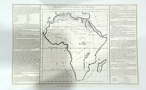
This item is an antique-style monochrome map print titled 'Description Générale de l’Afrique'. The central graphic features a map of the African continent with topographical markings such as mountain ranges, rivers, and regional labels in Latin, including 'Terra Incognita' across the central region and 'Africa Interior' in the north. The map is bordered by extensive French text columns on both the left and right sides, detailing various geographical sections like 'De L'Egypte' and 'De La Libye'. The print is executed on a rectangular, off-white or cream-colored paper stock with a visible black ink border. While designed to resemble an 18th-century copperplate engraving, certain characteristics such as the extreme crispness of the lettering and the modern English text at the bottom footer ('MAP OF AFRICA GEOGRAPHICA TABULA') suggest this is a high-quality modern reproduction or a 20th-century decorative lithograph rather than an original period artifact. The condition appears excellent with no visible foxing, tears, or creases, and the ink remains uniformly dark. The layout adheres to a classical encyclopedic style, utilizing several different font weights and sizes to organize information around the central cartographic image.