Appraisal
Historical Map Art Appraisal
Get AI-powered appraisal estimates for your Historical Map Art. Upload a photo for instant valuation.
Recent historical map art appraisals
Art & Collectibles
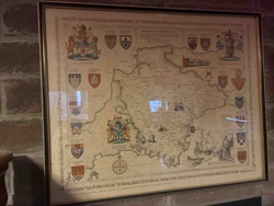
Framed Pictorial Map of County Durham
Framed Map
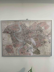
Framed 'ROMA PRESENTE E AVVENIRE' Map
Framed Map / Art
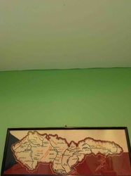
Framed Map of Czechoslovakia (Stylized)
Art and Collectibles - Cartography / Wall Decor
Framed Reproductions of Visscher and Hondius Maps of America

Reproduction Map / Wall Art
Reproduction Antique World Map
Art & Antique Map Reproductions
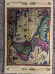
Novissima Totius Orbis Tabula by Carolum Allard
Historical Map
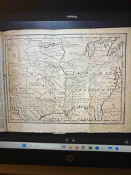
1763 Map of a Portion of North America from Gentlemen's Magazine
Cartographic Prints & Maps
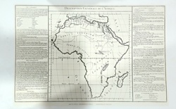
Description Générale de l’Afrique - Antique Style Map Print
Art and Wall Decor / Cartography Reproductions
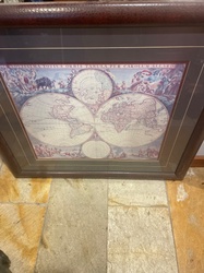
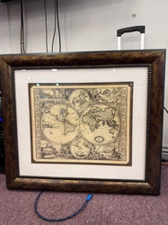
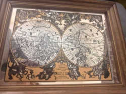
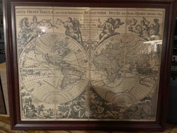
Reproduced 17th Century Style Double Hemisphere World Map
Antique Map Reproductions / Cartography
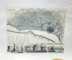
Antiquarian Map of Calcutta and the Hoogly River
Art & Collectibles
Framed Pictorial Map of County Durham
Framed Map
Framed 'ROMA PRESENTE E AVVENIRE' Map
Framed Map / Art
Framed Map of Czechoslovakia (Stylized)
Art and Collectibles - Cartography / Wall Decor
Framed Reproductions of Visscher and Hondius Maps of America
Reproduction Map / Wall Art
Reproduction Antique World Map
Art & Antique Map Reproductions
Novissima Totius Orbis Tabula by Carolum Allard
Historical Map
1763 Map of a Portion of North America from Gentlemen's Magazine
Cartographic Prints & Maps
Description Générale de l’Afrique - Antique Style Map Print
Art and Wall Decor / Cartography Reproductions
Reproduced 17th Century Style Double Hemisphere World Map
Antique Map Reproductions / Cartography
Antiquarian Map of Calcutta and the Hoogly River
Decorative Art / Wall Decor
Framed Antique World Map Reproduction
Decorative Art / Map Reproduction
Reproduction Antique Map of The Americas
Decorative Art / Map
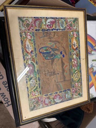
Framed Hand-Colored Chinese Map of China with Decorative Border
Decorative Wall Art / Cartography
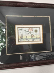
Vintage-Style Map of The Sandwich Isles (Hawaii) Illustration

Decorative Art / Map Reproduction
Nova Totius Terrarum Orbis Geographica ac Hydrographica Tabula (Old World Map Reproduction)
Framed Art/Map
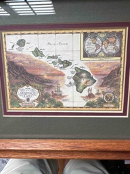
Framed 'Map of The Sandwich Isles' Decorative Print
Decorative Art / Map Reproduction
Nova Orbis Tabula World Map Reproduction (Authore H. Jaillot, Parisiis 1694)

Antique Cartography and Fine Art Prints
Antique Engraved Map of the Province of Essex

Antique Maps
Vintage Lake Minnetonka Map
Decorative Arts / Cartographic Memorabilia
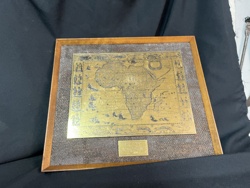
Etched Brass African Map Commemorative Plaque
Decorative Art / Wall Decor
Framed Antique World Map Reproduction
Decorative Art / Map Reproduction
Reproduction Antique Map of The Americas
Decorative Art / Map
Framed Hand-Colored Chinese Map of China with Decorative Border
Decorative Wall Art / Cartography
Vintage-Style Map of The Sandwich Isles (Hawaii) Illustration
Decorative Art / Map Reproduction
Nova Totius Terrarum Orbis Geographica ac Hydrographica Tabula (Old World Map Reproduction)
Framed Art/Map
Framed 'Map of The Sandwich Isles' Decorative Print
Decorative Art / Map Reproduction
Nova Orbis Tabula World Map Reproduction (Authore H. Jaillot, Parisiis 1694)
Antique Cartography and Fine Art Prints
Antique Engraved Map of the Province of Essex
Antique Maps
Vintage Lake Minnetonka Map
Decorative Arts / Cartographic Memorabilia
Etched Brass African Map Commemorative Plaque
Process
How our AI historical map art appraisal works
- 01
Upload your photo
Take a clear photo of your historical map art and upload it. One photo is all you need.
- 02
AI analysis
Our advanced AI technology analyzes your item.
- 03
Receive estimate
Get a detailed appraisal report with estimated value range, market insights, and item details.
Get the best appraisal
For the best results
- Use good lighting to capture all details
- Place item on a neutral background
- Include any identifying marks or labels
- Ensure the entire item is visible in frame
Ready to appraise your historical map art?
Get your free AI-powered appraisal in under 60 seconds
No registration required · Free to use · Instant results