Appraisal
Antiquarian Map Russie Deurope 1850 Appraisal
Get AI-powered appraisal estimates for your Antiquarian Map Russie Deurope 1850. Upload a photo for instant valuation.
Recent antiquarian map russie deurope 1850 appraisals

Antique Cartography and Paper Ephemera
Antiquarian Map: Russie d'Europe, 1850
Cartography & Antiquarian Maps
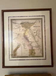
Samuel Augustus Mitchell Antique Framed Map of Egypt
Antiquarian Maps and Prints
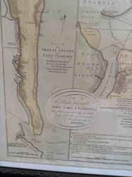
Plan of Amelia Island in East Florida by William Fuller
Antique Prints and Cartography
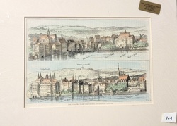
Antiquarian Hand-Colored Print: The Strand from the Thames, Sixteenth Century
Antiquarian Books
Copyright 1890 C. C. Parker Dictionary
Antiquarian & Collectible Books
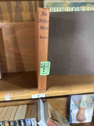
No Other Man by Alfred Noyes (Hardcover Edition)
Antique Maps and Cartography
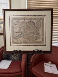
Samuel Augustus Mitchell 'County Map of Virginia and North Carolina' (c. 1860-1867)
Furniture / Home Decor - Rustic Breweriana
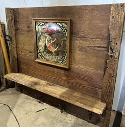
Reclaimed Wood Hat and Coat Rack with Vintage Miller High Life Bar Mirror
Antique Cartography and Paper Ephemera
Antiquarian Map: Russie d'Europe, 1850
Cartography & Antiquarian Maps
Samuel Augustus Mitchell Antique Framed Map of Egypt
Antiquarian Maps and Prints
Plan of Amelia Island in East Florida by William Fuller
Antique Prints and Cartography
Antiquarian Hand-Colored Print: The Strand from the Thames, Sixteenth Century
Antiquarian Books
Copyright 1890 C. C. Parker Dictionary
Antiquarian & Collectible Books
No Other Man by Alfred Noyes (Hardcover Edition)
Antique Maps and Cartography
Samuel Augustus Mitchell 'County Map of Virginia and North Carolina' (c. 1860-1867)
Furniture / Home Decor - Rustic Breweriana
Reclaimed Wood Hat and Coat Rack with Vintage Miller High Life Bar Mirror
Antique Map Reproductions / Cartography
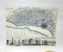
Antiquarian Map of Calcutta and the Hoogly River

Antiquarian Maps and Cartography
Ptolemaic Map of India Intra Gangem (Asia Table X)
Antique Maps and Prints
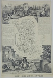
Antiquarian Map of the Département des Deux-Sèvres from Atlas National Illustré
Cartographic Illustration / Educational Graphic
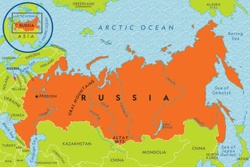
Illustrated Political Map of Russia
Antiquarian Books
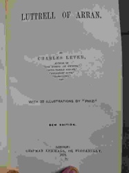
Luttrell of Arran by Charles Lever (1870 Edition)
Maritime Antiques / Scale Models
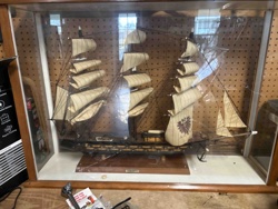
Large Scale Wooden 18th-Century Russian Man-of-War Ship Model

Vintage Periodicals
Satirical humor magazine in the style of Mad Magazine No. 180
Antique Map Reproductions / Cartography
Antiquarian Map of Calcutta and the Hoogly River
Antiquarian Maps and Cartography
Ptolemaic Map of India Intra Gangem (Asia Table X)
Antique Maps and Prints
Antiquarian Map of the Département des Deux-Sèvres from Atlas National Illustré
Cartographic Illustration / Educational Graphic
Illustrated Political Map of Russia
Antiquarian Books
Luttrell of Arran by Charles Lever (1870 Edition)
Maritime Antiques / Scale Models
Large Scale Wooden 18th-Century Russian Man-of-War Ship Model
Vintage Periodicals
Satirical humor magazine in the style of Mad Magazine No. 180
Process
How our AI antiquarian map russie deurope 1850 appraisal works
- 01
Upload your photo
Take a clear photo of your antiquarian map russie deurope 1850 and upload it. One photo is all you need.
- 02
AI analysis
Our advanced AI technology analyzes your item.
- 03
Receive estimate
Get a detailed appraisal report with estimated value range, market insights, and item details.
Get the best appraisal
For the best results
- Use good lighting to capture all details
- Place item on a neutral background
- Include any identifying marks or labels
- Ensure the entire item is visible in frame
Ready to appraise your antiquarian map russie deurope 1850?
Get your free AI-powered appraisal in under 60 seconds
No registration required · Free to use · Instant results