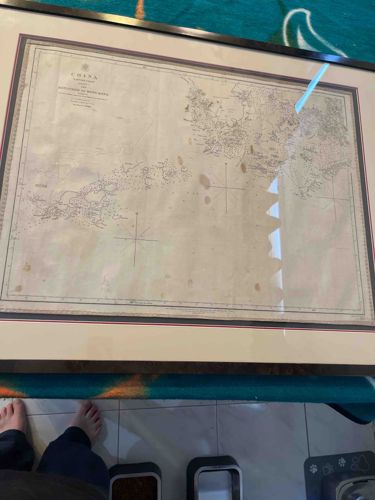
Antique Framed British Admiralty Nautical Chart of the China Sea
Antiques & Collectibles - Maps and Cartography

Antique Framed British Admiralty Nautical Chart of the China Sea

This item is a large-format, framed nautical chart of the China Sea, focused on the coast from Canton (Guangzhou) to Hong Kong, likely dating from the mid-to-late 19th century based on the cartographic style. The chart is printed on heavy off-white paper and features highly detailed topographical renderings of coastlines, soundings, and navigational rhumb lines. The title block in the upper left corner explicitly mentions 'CHINA' and references surveys by British officers, typical of Admiralty publications during the Victorian era. The map is housed in a modern black frame with a wide, neutral-toned mat that includes a thin red and black decorative border. Physically, the paper shows significant signs of age and patina, most notably foxing and several reddish-brown moisture stains (tidemarks) scattered across the center-right section, which suggests historical exposure to humidity. Fine copperplate engraving is evident in the precise lettering and hatched coastal details. The condition is fair to good; while the integrity of the image remains, the staining impacts the visual clarity of the central region. This piece represents a fine example of colonial-era hydrography and British maritime mapping efforts in East Asia.

Estimated Value

$1,200 - $1,800

Basic Information

Category

Antiques & Collectibles - Maps and Cartography

Appraised On

February 20, 2026

Estimated Value

$1,200 - $1,800

Item Description

This item is a large-format, framed nautical chart of the China Sea, focused on the coast from Canton (Guangzhou) to Hong Kong, likely dating from the mid-to-late 19th century based on the cartographic style. The chart is printed on heavy off-white paper and features highly detailed topographical renderings of coastlines, soundings, and navigational rhumb lines. The title block in the upper left corner explicitly mentions 'CHINA' and references surveys by British officers, typical of Admiralty publications during the Victorian era. The map is housed in a modern black frame with a wide, neutral-toned mat that includes a thin red and black decorative border. Physically, the paper shows significant signs of age and patina, most notably foxing and several reddish-brown moisture stains (tidemarks) scattered across the center-right section, which suggests historical exposure to humidity. Fine copperplate engraving is evident in the precise lettering and hatched coastal details. The condition is fair to good; while the integrity of the image remains, the staining impacts the visual clarity of the central region. This piece represents a fine example of colonial-era hydrography and British maritime mapping efforts in East Asia.

Get Your Items Appraised

Instant estimates of your treasures with AI-powered instant appraisals

Browse More Appraisals