Appraisal
Vermont Map Appraisal
Get AI-powered appraisal estimates for your Vermont Map. Upload a photo for instant valuation.
Recent vermont map appraisals
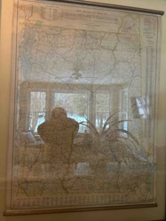
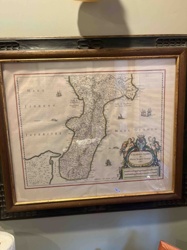
Antique Cartography and Vintage Paper Ephemera
The Official Map of Vermont and New Hampshire by National Survey
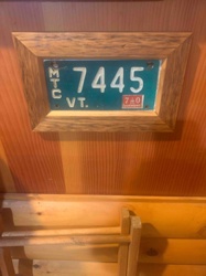
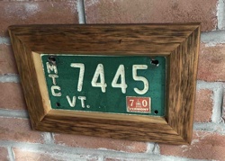
Collectibles / Automobilia
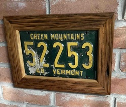
Framed Vintage Vermont Motorcycle License Plate
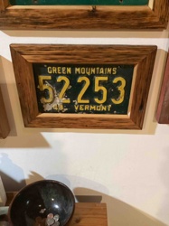
Collectibles / Automobilia & Folk Art
Framed Vintage 1970 Vermont Trailer License Plate in Reclaimed Barnwood
Collectibles / Automobiliana / Home Decor
Framed 1948 Vermont License Plate in Reclaimed Barnwood
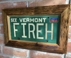
Automobilia / Folk Art Decor
Framed 1970 Vermont License Plate 'FIREH' from Arlington Fire House
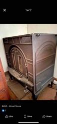
Home Appliances / Antique & Vintage Heating Stoves
Vermont Castings Defiant Wood Burning Stove

Antique Maps
Vintage Lake Minnetonka Map
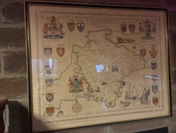
Art & Collectibles
Framed Pictorial Map of County Durham

Antique Maps
Antique World Map
Antiques & Collectibles - Cartography
Calabria Citra framed antique-style map
Antique Cartography and Vintage Paper Ephemera
The Official Map of Vermont and New Hampshire by National Survey
Collectibles / Automobilia
Framed Vintage Vermont Motorcycle License Plate
Collectibles / Automobilia & Folk Art
Framed Vintage 1970 Vermont Trailer License Plate in Reclaimed Barnwood
Collectibles / Automobiliana / Home Decor
Framed 1948 Vermont License Plate in Reclaimed Barnwood
Automobilia / Folk Art Decor
Framed 1970 Vermont License Plate 'FIREH' from Arlington Fire House
Home Appliances / Antique & Vintage Heating Stoves
Vermont Castings Defiant Wood Burning Stove
Antique Maps
Vintage Lake Minnetonka Map
Art & Collectibles
Framed Pictorial Map of County Durham
Antique Maps
Antique World Map
Antiques & Collectibles - Cartography
Calabria Citra framed antique-style map
Automobilia / Folk Art Decor
Framed 1962 Vermont Trailer License Plate
Numismatics / Coins
2001 Vermont State Quarter
Collectibles & Folk Art Decor
Framed 1962 Vermont Trailer License Plate Art
Collectibles / Automobilia & Folk Art
Framed 1962 Vermont Trailer License Plate in Reclaimed Barnwood
Collectibles & Automobilia
1948 Vermont License Plate in Reclaimed Barnwood Frame
Antique Map Reproductions / Cartography
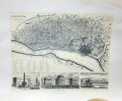
Antiquarian Map of Calcutta and the Hoogly River
Decorative Art / Map
Framed Hand-Colored Chinese Map of China with Decorative Border

Antique Cartography and Printed Maps
A New & Accurate Map of North America (c. 1790s)

Antique Maps and Prints
Victor Levasseur Antique Map of the Tarn-et-Garonne Department
Art and Collectibles - Cartography / Wall Decor
Framed Reproductions of Visscher and Hondius Maps of America
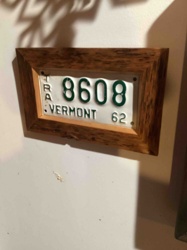
Automobilia / Folk Art Decor
Framed 1962 Vermont Trailer License Plate
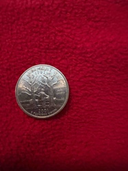
Numismatics / Coins
2001 Vermont State Quarter
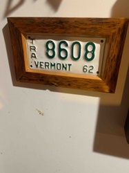
Collectibles & Folk Art Decor
Framed 1962 Vermont Trailer License Plate Art
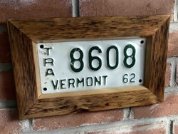
Collectibles / Automobilia & Folk Art
Framed 1962 Vermont Trailer License Plate in Reclaimed Barnwood
Collectibles & Automobilia
1948 Vermont License Plate in Reclaimed Barnwood Frame
Antique Map Reproductions / Cartography
Antiquarian Map of Calcutta and the Hoogly River
Decorative Art / Map
Framed Hand-Colored Chinese Map of China with Decorative Border
Antique Cartography and Printed Maps
A New & Accurate Map of North America (c. 1790s)
Antique Maps and Prints
Victor Levasseur Antique Map of the Tarn-et-Garonne Department
Art and Collectibles - Cartography / Wall Decor
Framed Reproductions of Visscher and Hondius Maps of America
Process
How our AI vermont map appraisal works
- 01
Upload your photo
Take a clear photo of your vermont map and upload it. One photo is all you need.
- 02
AI analysis
Our advanced AI technology analyzes your item.
- 03
Receive estimate
Get a detailed appraisal report with estimated value range, market insights, and item details.
Get the best appraisal
For the best results
- Use good lighting to capture all details
- Place item on a neutral background
- Include any identifying marks or labels
- Ensure the entire item is visible in frame
Ready to appraise your vermont map?
Get your free AI-powered appraisal in under 60 seconds
No registration required · Free to use · Instant results