AI Appraisal Estimate

AI-generated estimates · not official valuations

From the user

What was submitted

Photo and notes provided by the user — not generated by AI

Submitted item photo
Submitted photo · May 31, 2026

User's notes

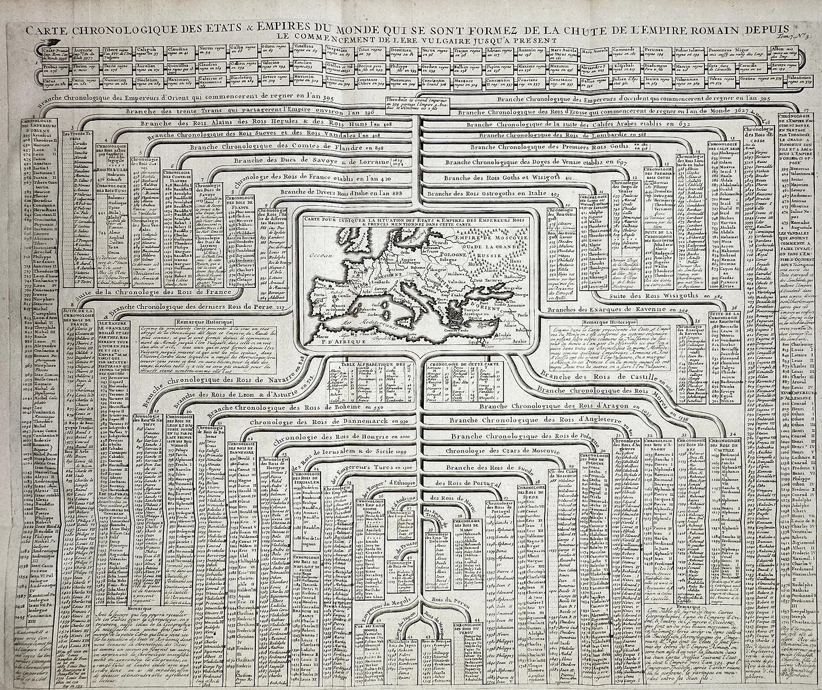
"Carte Chronologique des Etats & Empires du Monde" presents a sophisticated genealogical and historical tree centering on a small map of Europe, the Mediterranean, and the Middle East. The chart traces the development and succession of global powers from the fall of the Roman Empire to the early eighteenth century, utilizing branching lines to show the origins of various European monarchies and Eastern caliphates. This engraving was published in the first volume of the Atlas Historique, issued in Amsterdam by L'Honore & Chatelain between 1705 and 1720. Henri Abraham Chatelain was a Dutch Huguenot scholar whose innovative atlas was designed to present a total history of the world through a visual and cartographic lens. His work is celebrated for its ability to condense vast amounts of complex data into organized, pedagogical diagrams that served as essential reference tools for the Enlightenment era's educated public. Artist or Maker: Henri Abraham Chatelain. Dimensions: Approximately 46 cm x 30 cm. Medium: Engraving. Date: 1705.

AI analysis below

AI appraisal

AI analysis & estimate

AI-Generated · Verify before acting

Everything below is generated by AI for informational purposes only. AI can make mistakes — the AI may misidentify items or misattribute them (artist, maker, brand, designer, origin, era). This is not an official valuation and should not be used for insurance, sale, tax, estate, legal, or lending purposes — or any decision requiring a certified appraisal. It is not an authoritative claim about any person, brand, or rights holder — do not share or rely on it as a factual statement about a third party. Always consult qualified professionals before making financial decisions.

Note

This analysis also relies on unverified notes provided by the user, which may be incomplete or inaccurate and could affect the result.

Read the full disclaimer

AI Identification

·Not independently authenticated·Verify before acting

18th-century style chronological and genealogical chart engraving

Antique Prints and Maps

AI Estimated Value

·Not an official valuation·Verify before acting

$400 - $650

As of May 31, 2026

AI Item Analysis

·AI can make mistakes·Verify before acting
This item is an intricate engraved chart titled 'CARTE CHRONOLOGIQUE DES ETATS & EMPIRES DU MONDE...', featuring a central map and a dense network of branching genealogical and historical lines. The layout displays a central topographic map of Europe, the Mediterranean, and North Africa, surrounded by structured columns and banners containing historical text, names of rulers, and dynastic dates. The engraving appears to be on laid paper, exhibiting a monochromatic ink finish with visible fine-line hatching and scrollwork consistent with early 18th-century European cartographic practices. The header explicitly mentions the fall of the Roman Empire, and various sidebars provide 'Remarque Historique' annotations. The owner attributes this work to Henri Abraham Chatelain, dated approximately 1705-1720 from the 'Atlas Historique', though this attribution remains unverified without a physical examination of the paper, watermark, and plate marks. The craftsmanship reflects a high degree of pedagogical organization typical of Enlightenment-era scholarship. No significant physical damage is immediately visible in the image, though characteristic paper aging and slight tonal variations are consistent with historical prints from the 1700s.
AI Appraisal Report

·AI can make mistakes·Verify before acting
I have evaluated the provided image of the genealogical and chronological chart titled 'CARTE CHRONOLOGIQUE DES ETATS & EMPIRES DU MONDE.' Per user submission, the work is attributed to Henri Abraham Chatelain for the 'Atlas Historique,' dated approximately 1705-1720. While the engraving exhibits the sophisticated pedagogical layout and fine-line hatching consistent with 18th-century Dutch cartographic practices, I cannot verify the paper's age, watermark, or the presence of genuine plate marks from a photograph. The estimate assumes the piece is a period strike from the original plate. If confirmed as a 1705-1720 edition, similar Enlightenment-era charts typically command $400 to $650 in the current market, as there is steady demand for Chatelain’s works due to their decorative and intellectual appeal. However, if physical inspection reveals it to be a later 19th-century reproduction or a modern offset lithograph, the value would likely drop below $50. To confirm the piece's status, an in-person examination by a paper conservator or antique print specialist is required to analyze the chain lines, ink absorption, and paper texture. The current condition appears stable with expected tonal variations, but any hidden foxing or trimmed margins would negatively impact the valuation. This estimate is contingent upon the accuracy of the owner's attribution.

Get your items appraised

Instant estimates of your treasures with AI-powered appraisals

Browse More Appraisals