Appraisal
Nautical Map Print Telescopes Appraisal
Get AI-powered appraisal estimates for your Nautical Map Print Telescopes. Upload a photo for instant valuation.
Recent nautical map print telescopes appraisals
Optical Instruments/Decorative Collectibles
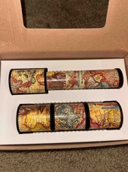
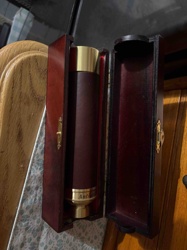
Nautical Map Print Telescopes/Kaleidoscopes (Pair)
Art - Mixed Media & Prints
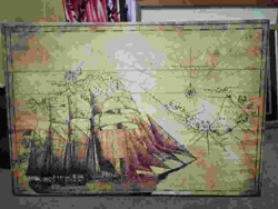
Signed and Numbered Nautical Tall Ship Canvas Map Art

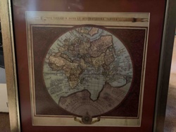
Antique Maps
Vintage Lake Minnetonka Map
Framed Art/Map
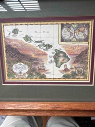
Framed 'Map of The Sandwich Isles' Decorative Print

Telescope
TeleStar 114 by Meade Telescope
Cartographic Prints & Maps
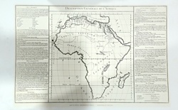
Description Générale de l’Afrique - Antique Style Map Print
Antiques & Collectibles - Cartography
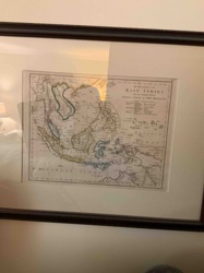
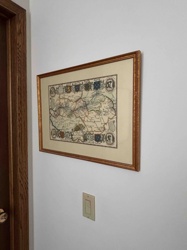
Framed 19th Century Map of the East Indies with the Channels between India, China & New Holland

Antique Cartography and Fine Art Prints
Antique Engraved Map of the Province of Essex
Print/Map
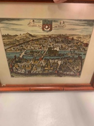
Historic Map/View of Paris (Lutetia) c. 1600
Art and Collectibles - Cartography / Wall Decor
Framed Reproductions of Visscher and Hondius Maps of America
Optical Instruments/Decorative Collectibles
Nautical Map Print Telescopes/Kaleidoscopes (Pair)
Art - Mixed Media & Prints
Signed and Numbered Nautical Tall Ship Canvas Map Art
Antique Maps
Vintage Lake Minnetonka Map
Framed Art/Map
Framed 'Map of The Sandwich Isles' Decorative Print
Telescope
TeleStar 114 by Meade Telescope
Cartographic Prints & Maps
Description Générale de l’Afrique - Antique Style Map Print
Antiques & Collectibles - Cartography
Framed 19th Century Map of the East Indies with the Channels between India, China & New Holland
Antique Cartography and Fine Art Prints
Antique Engraved Map of the Province of Essex
Print/Map
Historic Map/View of Paris (Lutetia) c. 1600
Art and Collectibles - Cartography / Wall Decor
Framed Reproductions of Visscher and Hondius Maps of America
Wall Art & Decor
Framed Nautical Caribbean Map Print by T. Pinto
Maritime Collectibles / Decorative Scientific Instruments
Brass and Leather Nautical Spyglass in Wooden Presentation Case
Wall Art
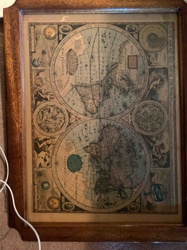
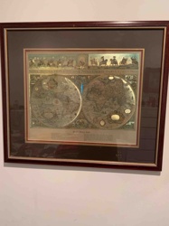
Framed Antique Style World Map Print
Framed Map/Print
Framed Antique-Style World Map Print
Framed Map Print
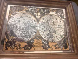
Framed Antique Style World Map Print 'Nova Totius Terrarum Orbis Tabula'

Optical Instruments & Scientific Equipment
Meade Professional/Reflector Telescope in original retail box
Wall Art / Decorative Prints
Carte de Vins de France (Wine Map of France) Reproduction Print
Art / Wall Decor
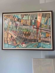
Abstract Urban Landscape Map Print
Antiques & Collectibles - Maps and Cartography
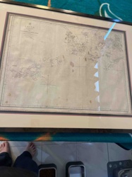
Antique Framed British Admiralty Nautical Chart of the China Sea
Decorative Art / Wall Decor
Framed Antique World Map Reproduction
Wall Art & Decor
Framed Nautical Caribbean Map Print by T. Pinto
Maritime Collectibles / Decorative Scientific Instruments
Brass and Leather Nautical Spyglass in Wooden Presentation Case
Wall Art
Framed Antique Style World Map Print
Framed Map/Print
Framed Antique-Style World Map Print
Framed Map Print
Framed Antique Style World Map Print 'Nova Totius Terrarum Orbis Tabula'
Optical Instruments & Scientific Equipment
Meade Professional/Reflector Telescope in original retail box
Wall Art / Decorative Prints
Carte de Vins de France (Wine Map of France) Reproduction Print
Art / Wall Decor
Abstract Urban Landscape Map Print
Antiques & Collectibles - Maps and Cartography
Antique Framed British Admiralty Nautical Chart of the China Sea
Decorative Art / Wall Decor
Framed Antique World Map Reproduction
Process
How our AI nautical map print telescopes appraisal works
- 01
Upload your photo
Take a clear photo of your nautical map print telescopes and upload it. One photo is all you need.
- 02
AI analysis
Our advanced AI technology analyzes your item.
- 03
Receive estimate
Get a detailed appraisal report with estimated value range, market insights, and item details.
Get the best appraisal
For the best results
- Use good lighting to capture all details
- Place item on a neutral background
- Include any identifying marks or labels
- Ensure the entire item is visible in frame
Ready to appraise your nautical map print telescopes?
Get your free AI-powered appraisal in under 60 seconds
No registration required · Free to use · Instant results